U.S.P.R.R. SURVEY LITHOGRAPHS (1855)
Lithographs from the United States Pacific Rail Road Surveys
HISTORY
In 1853, the U.S. congress sent several teams of surveyors from the Corps of Topographical Engineers to survey potential rail routes from the Misssissippi to the Pacific. They were accompanied by naturalists and artists who were to capture the images of the "wild west". It was a dangerous expedition with Captain John W. Gunnison, artist R.H Kern, and seven others from Gunnison's survey team being killed in October of 1853, by the Ute Indians in Utah. These lithographs were part of the official government report which would ultimately determine the rail route and forever change the United States.
ORDER
Main 1 2 3 4 5 6 7 8 |
|
|
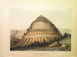
| A Conical Hill 500 feet high |
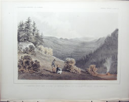
| Bivouac - Jan 26 |
| Bivouac - Jan 28 |
| Camp Scene In The Mojave Valley Of Rio Colorado |
| Canadian River Near Camp 38 |
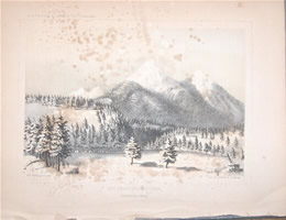
| Cascade Range With Mount Jefferson... |
| Castle Rock In Canon Of Mpto-Ly-As River... |
| Colorado Desert And Signal Mountain |
| Comanche Camp Of Shady Creek |
| Coo-Che-To- Pa Pass |
| Crossing Of Chowchillas River |
|
|
| Diamond Peak And Ravine Of Middle Fork... |
| Entrance Of Livermores Pass |
| Entrance Of The Tejon Pass |
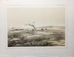
| Fort Massachusetts |
| Fort Smith Arkansas |
| Great Basin From The Summit of the Tejon Pass |
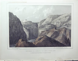
| Head of the first Canon Of Grand River |
| Indian Altar And Ruins of old Zuni |
| Lassens Butte From Vicinity Of Camp 18 |
| |
|
|
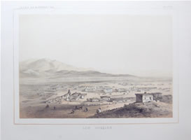
| Los Angeles |
| Lost Mountains in the Great Basin |
| Metamorphic Rock - Borders Of The Desert |
| Mirage On The Colorado Desert |
| Mission And Plain Of San Fernando |
| Mojave Indians |
| Mount Hood From Tysch Prairie |
| Mountains Near The Entrance, Canada De Las Uvas |
| |
|
|
| Mount Pitt. Klamath River |
| Mouth Of Fall River Near Camp M |
| Peaks Of The Sierra Blanca |
| Plain Between The San Joaquin And Kings Rivers |
| Plain Between Kah-Wee-Ya And Kings Rivers |
| Porphyritic Statue Peloncillo Range |
| Rio Colorado - Near The Mojave - View No 1 |
| Rio Colorado - Near The Mojave - View No 2 |
| Rock Hills Between Green and White Rivers |
| Rounded Hils, Tertiary |
| |
|
|
| San Francisco Mountain |
| Sangre De Cristo Pass - San Luis Valley |
| Sangre De Cristo Pass From Near The Summit |
| Shasta Butte And Shasta Valley |
| South End of S. Inez Mountains |
| Summit Of The Nearest Ridges South Of Grand River |
| The Great Basin From The Canada De Las Uvas |
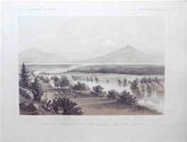
| Three Sisters - Willamette River |
| Upper Klamath Lake From Camp 28 |
| |
|
|
| US Military Post Benicia |
| Valley Of The Aravaypa From Bear Springs |
| Valley Of La Cuesta Rio Pecos |
| Vally Of The Gilla |
| Valley Of The Kah-Wee-Ya River |
| Valley In the Slope Of The Great Basin |
| Valley Of Williams River |
| View Of Benecia From The West |
| View Of The Black Forest Mountain |
| |
|
|
| View...Formation of the Canon Of Grand River |
| View Of The Gilla Below The Great Bend |
| View Of Ordinary Lateral Ravines On Grand River |
| View Of The Roan or Book Mountains |
| View Of Sangre De Cristo Pass |
| Waterline And Shores Of The Ancient Lake. Colorado |
|
| |
| |
|
|
| Juniperus Occidentalis |
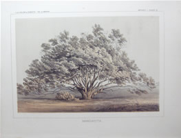
| Manzanita |
| Picea Grandus |
| Pinus Contorta |
| Pinus Ponderosa |
| Platanus Racemosa |
| Quercus Hinds II |
| |
| |
|
|